
Satellite LiDAR Study Reveals Ancient Colombian Water Systems Were Built Without Centralized Leadership
High-precision LiDAR mapping and spatial analysis show that pre-Hispanic agricultural and hydraulic networks in La Mojana were constructed through community self-organization rather than elite rule.
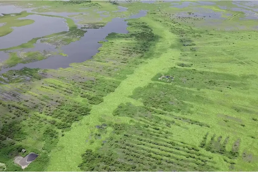
A recent scientific study combining satellite imagery and high-resolution LiDAR data has challenged long-held archaeological assumptions about ancient monumental infrastructure. Researchers investigating the pre-Hispanic hydraulic networks of the Zenú culture in Colombia’s La Mojana region have concluded that massive earthworks and canal systems were built and maintained through decentralized community self-organization rather than by a centralized ruling elite.
For decades, the sheer scale of the earthworks across the Caribbean basin led researchers to assume that hierarchical management was required to plan and execute such massive civil engineering projects. The new study tests this hypothesis by calculating the physical volume of earth moved and cross-referencing it with human labor capacity, offering a quantitative look at ancient large-scale resource management.
Key facts
Metric | Value | Context
Region | La Mojana, Colombia | Confluence of Magdalena, Cauca, and San Jorge rivers
Study Area | 500 hectares | Extrapolated from over 500,000 hectares of total system
Estimated Labor | ~800 workers | Capable of building the sampled infrastructure in 1.5 months
Dating | 1st century BCE to 11th century CE | Period of active construction and hydraulic management
Mapping Earthworks and Labor Capacity
The research team mapped 1,601 agricultural ridges and 63 residential platforms across a 500-hectare study area using satellite data and digital elevation models derived from LiDAR. By calculating the exact volume of soil moved for each structure, the authors estimated that roughly 800 individuals working together could construct the entire network in less than a month and a half.
This timeline indicates that the construction could be achieved by roughly half of the local population during the dry season. Furthermore, ongoing maintenance would require only a few days of communal labor per year, with complete system overhauls needed roughly every quarter-century. Longer ridges that would have posed significant challenges for a single family could be completed in a matter of days when undertaken collectively.
Rethinking Monumental Infrastructure
According to the study, this is one of the first quantitative demonstrations that public works of this scale do not inherently require coercive authority, elite direction, or a ruling class. The spatial distribution of larger residential platforms near central network nodes suggests that these areas served as social, economic, or ritual gathering points rather than administrative command centers.
The hydraulic networks served a dual purpose in the seasonally flooded tropical wetlands: capturing and storing water during rainy periods to release it during dry spells, mitigating both floods and droughts, and allowing elevated crop cultivation alongside fishing grounds. Modern engineering efforts in the same flood-prone basins frequently struggle with maintenance issues, making the ancient sustainable model an ongoing subject of environmental study.
Methodological Limitations and Next Steps
The authors note important caveats to their findings. Because the study analyzed a 500-hectare sample out of more than 500,000 hectares of total regional canals, the conclusions represent a localized extrapolation rather than a complete census of every site. Furthermore, without more absolute dating samples, it remains unproven whether all parts of the vast network operated simultaneously at peak capacity.
While the absence of a ruling chief does not mean there was a complete lack of social organization, the findings demonstrate how collaborative labor models can sustain complex environmental engineering over centuries.
Source: Xataka IA, https://www.xataka.com/magnet/satelites-revelan-que-colosales-canales-milenarios-cultura-zenu-colombiana-se-hicieron-jefes-caciques
Datos clave
| Punto | Detalle |
|---|---|
| Fuente | Xataka IA |
| Fecha | 2026-08-22T16:01:33+00:00 |
| Tema | Satélites revelan que los colosales canales milenarios de la cultura Zenú colombiana se hicieron sin jefes ni caciques |
Source
Xataka IA Publicacion original: 2026-08-22T16:01:33+00:00
Related articles

OCU Finds Spanish Homeowner Communities Overpaying Up to €1,500 on Electricity and €3,515 on Gas—Can AI Tools Optimize Shared Energy Bills?
A new OCU analysis of Spanish homeowner community bills reveals widespread overpayment due to non-competitive tariffs and excess contracted power. Could AI-driven…
Read article
Mayotte fiber dispute does not meet ReviewArticle’s AI news brief
Le Monde reports that France’s competition authority has ordered Orange to suspend part of its fiber-optic rollout in Mayotte. The dispute is…
Read article
DiffEEG Model Uses Diffusion Pre-Training to Improve Seizure Detection from Minimal Labeled Data
Researchers have introduced DiffEEG, a 9.6-million-parameter foundation model that combines denoising diffusion pre-training with reinforcement learning fine-tuning to detect seizure events from…
Read article
The Technology Trap: Why AI Cannot Escape the Unchanging Fundamentals of War
A new Foreign Affairs essay by former Pentagon official Mara Karlin warns that over-reliance on AI and advanced tech in military planning…
Read articleWiki relacionada

AI Model API Pricing and Context Window Comparison: Current Rates and Limits
Compare the latest API pricing, context windows, and capabilities of leading AI model providers including OpenAI, Anthropic, Google, and Mistral. Practical guidance…
Read article
AI Agent Evaluation Frameworks: How to Benchmark Agentic Systems
A practical guide to evaluating AI agents — from task completion metrics to safety, cost, and robustness. Covers major frameworks, primary sources,…
Read article
LLM Benchmarks Decoded: What MMLU, HumanEval, and GSM8K Actually Measure for Developers
A developer-focused breakdown of the most-cited LLM benchmarks — MMLU, HumanEval, GSM8K, MATH, Chatbot Arena — including what they test, their hidden…
Read article
What Is RAG? A Practical Guide to Retrieval-Augmented Generation in 2025
Retrieval-Augmented Generation (RAG) grounds LLM outputs in external data, reducing hallucinations and enabling enterprise use cases. This guide covers how RAG works,…
Read article