Deep-Sea Submersible Finds Shackleton’s Quest Shipwreck After 64 Years
A Canadian-led expedition used the deep-sea submersible Alvin and the remotely operated vehicle Falcon to locate and image the wreck of Ernest Shackleton’s final ship, the Quest, 390 meters down in the Labrador Sea.
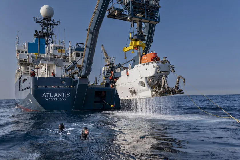
A joint expedition by the Royal Canadian Geographical Society (RCGS) and the Woods Hole Oceanographic Institution (WHOI) has located and photographed the wreck of the Quest, the last ship commanded by Antarctic explorer Ernest Shackleton. The discovery, made at a depth of 390 meters in the Labrador Sea off the coast of Canada, relied on two deep-sea vehicles: the manned submersible Alvin and the remotely operated vehicle (ROV) Falcon.
The Quest was a 34-meter steam-powered vessel that Shackleton used for the Shackleton–Rowett Expedition of 1921–1922. Shackleton died of a heart attack aboard the ship in South Georgia in January 1922, cementing the Quest’s place in polar exploration history. After decades of service in seal hunting and Arctic expeditions, the ship was crushed by an ice floe and sank on May 5, 1962, in the Atlantic Ocean.
A two-year search effort
The RCGS-led team first detected the wreck in 2024 using side-scan sonar. That survey confirmed the location but could not provide visual details. The 2026 expedition, using the Alvin and Falcon, was the first to directly observe the wreck and capture high-resolution video and still images.
“The sonar gave us a ghostly outline, but we needed to see it with our own eyes,” said John Geiger, the expedition leader. “The Alvin and Falcon allowed us to do that.”
The Alvin, a deep-sea submersible capable of carrying up to three people to depths of 4,500 meters, was deployed from the research vessel. The Falcon ROV, a tethered robot, was used to maneuver around the wreckage and inspect areas too dangerous for the manned submersible.
Wreck condition and unexpected ecology
The images reveal that the Quest is in poorer condition than the sonar suggested. The stern and starboard side are covered in fishing nets and debris. The bridge area, where the ship’s name once appeared, has collapsed. However, the wreck has become a thriving artificial reef, hosting corals, cod, redfish, and wolf fish.
“The different materials in the ship have created microhabitats,” said Antoine Normandin, the mission’s lead scientist. “We are seeing layered biodiversity around the wreck that is becoming a scientific experiment in marine colonization.”
The RCGS and WHOI plan to release a full report later this year, including a 3D photogrammetric model of the site.
Technology at the core of the discovery
The success of the mission highlights the role of advanced underwater robotics in historical archaeology. The combination of a manned submersible (Alvin) and a remotely operated vehicle (Falcon) allowed the team to both observe from a safe distance and perform close-up inspection. The Falcon ROV was able to clear some debris to reveal structural details, while Alvin provided the human perspective needed to interpret the wreck’s context.
The expedition also tested new navigation and imaging systems that could be used for future deep-sea searches. The team used a combination of sonar data, GPS coordinates from historical records, and computer modeling to narrow the search area.
What remains unclear
The exact cause of the sinking is not in doubt – the ship was crushed by ice – but the extent of structural damage from fishing nets versus natural decay is still being analyzed. The RCGS has not yet confirmed whether any artifacts from Shackleton’s time remain intact. The ship was modified several times after his death, and the original cabin where Shackleton died is likely destroyed.
Also unclear is whether the site will be designated a protected heritage area. The Canadian government has not yet commented on the discovery.
Source: Original report by Carlos Prego at Xataka, published July 29, 2026. Additional details from the Royal Canadian Geographical Society and Woods Hole Oceanographic Institution press releases.
Datos clave
| Punto | Detalle |
|---|---|
| Fuente | Xataka IA |
| Fecha | 2026-07-29T11:15:36+00:00 |
| Tema | Canadá envió un submarino a 400 metros frente a Groenlandia. Ha encontrado el naufragio del legendario barco de Shacklet |
Source
Xataka IA Publicacion original: 2026-07-29T11:15:36+00:00
Related articles

AI-Driven Models Now Track Invasive Acacia Spread Across Post-Fire Landscapes in Spain
Researchers are using machine learning and satellite data to map how Acacia dealbata, introduced in 1824, exploits wildfires to colonize new terrain…
Read article
IBM CEO Puts a Number on the Open-Weight AI Value Proposition: 90% of the Performance at 10% of the Token Cost
IBM CEO Arvind Krishna told analysts that open-weight models now deliver about 90% of frontier-model effectiveness while costing between 10% and 25%…
Read article
OCU Finds Spanish Homeowner Communities Overpaying Up to €1,500 on Electricity and €3,515 on Gas—Can AI Tools Optimize Shared Energy Bills?
A new OCU analysis of Spanish homeowner community bills reveals widespread overpayment due to non-competitive tariffs and excess contracted power. Could AI-driven…
Read article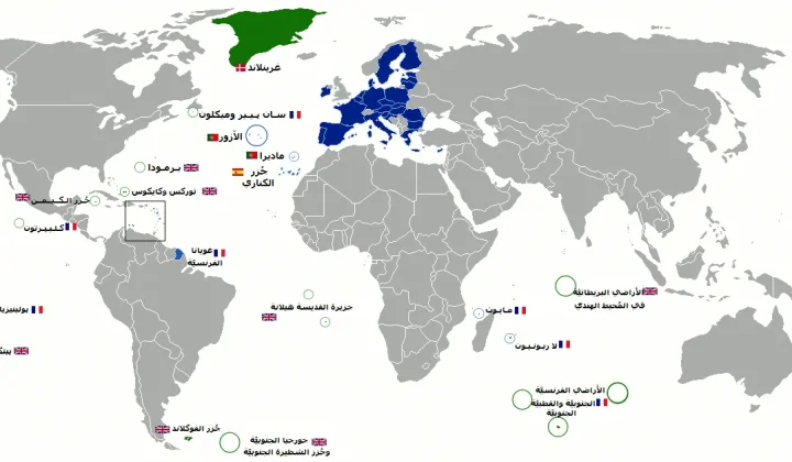
Mayotte fiber dispute does not meet ReviewArticle’s AI news brief
Le Monde reports that France’s competition authority has ordered Orange to suspend part of its fiber-optic rollout in Mayotte. The dispute is…
Read articleWiki relacionada
AI Model API Pricing and Context Window Comparison: Current Rates and Limits
Compare the latest API pricing, context windows, and capabilities of leading AI model providers including OpenAI, Anthropic, Google, and Mistral. Practical guidance…
Read article
AI Agent Evaluation Frameworks: How to Benchmark Agentic Systems
A practical guide to evaluating AI agents — from task completion metrics to safety, cost, and robustness. Covers major frameworks, primary sources,…
Read article
LLM Benchmarks Decoded: What MMLU, HumanEval, and GSM8K Actually Measure for Developers
A developer-focused breakdown of the most-cited LLM benchmarks — MMLU, HumanEval, GSM8K, MATH, Chatbot Arena — including what they test, their hidden…
Read article
What Is RAG? A Practical Guide to Retrieval-Augmented Generation in 2025
Retrieval-Augmented Generation (RAG) grounds LLM outputs in external data, reducing hallucinations and enabling enterprise use cases. This guide covers how RAG works,…
Read article