
Roman Canal Discovery in Germany Reveals Advanced Roman Engineering North of the Alps
A newly identified Roman canal in Germany, stretching 15 meters wide and 2.5 meters deep, highlights the Empire's significant infrastructure development and logistical capabilities beyond its well-known road networks.
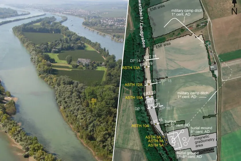
A significant archaeological discovery in southwestern Germany has revealed an extensive Roman canal, previously mistaken for a natural river meander. This artificial waterway, measuring 15 meters wide and 2.5 meters deep, connected the Rhine River to a military fort known as the burgus of Trebur-Astheim. The finding underscores the Roman Empire’s advanced engineering and logistical capabilities in regions north of the Alps, with the canal remaining operational for over 300 years after the Empire’s decline.
The research team, comprising experts from the Johannes Gutenberg University of Mainz, Christian-Albrechts University of Kiel, and the Hessian State Office for Monument Preservation, identified the canal through interdisciplinary research. The most compelling clue to its artificial nature was its remarkably straight and elongated form, a feature rarely observed in natural geological formations.
A Roman Logistical Hub
The canal’s importance lies in its function as one of the few known navigable waterways north of the Alps during the Roman period and the early Middle Ages. This infrastructure suggests that Roman presence in Germania was more than just military occupation; it involved significant landscape modification and strategic planning. The burgus of Trebur-Astheim likely served as a central logistical node, facilitating the transfer of goods from larger Rhine cargo ships to smaller vessels for distribution throughout the region. This indicates a sophisticated logistical vision for supplying Roman troops, extending beyond the well-documented road networks.
Historical Context
Roman consolidation in the Hessische Ried region began in the 1st century AD under the Flavian emperors. The Trebur-Astheim fort itself was constructed between 364 and 375 AD under Emperor Valentinian I as part of a broader military deployment along the Rhine aimed at containing Germanic tribes, specifically the Alemanni. The Rhine frontier was characterized by a network of watchtowers and forts, a system recognized by its inclusion in the UNESCO World Heritage List.
Engineering and Operation
The dimensions of the Trebur-Astheim canal were comparable to other known Roman navigable canals, such as the Fossa Corbulonis in the Netherlands. It was designed to accommodate various Roman river vessels, including military craft like the Mainz-A type and cargo barges found near Xanten, all of which had shallow drafts well within the canal’s depth. Carbon-14 dating of sediment samples indicates the canal was in use from the Roman era until the 7th-8th centuries AD. Its eventual abandonment is attributed to silting, a common issue that required frequent dredging throughout its operational life. Evidence suggests that Merovingian and Carolingian communities continued to utilize and maintain the infrastructure after the Roman period.
Limitations and Future Research
The 2024 excavation, while revealing the canal’s presence and estimated dimensions, was limited by high groundwater levels and sediment accumulation. This prevented direct observation of the canal’s walls, necessitating indirect methods for determining its size, a common practice in underwater archaeology. Further comprehensive excavation is planned to obtain direct data on the canal’s construction and precise dimensions.
Key facts
| Fact | Detail |
|—|—|
| Discovery | Large Roman artificial canal |
| Location | Southwestern Germany, near the Rhine River |
| Dimensions | 15 meters wide, 2.5 meters deep |
| Function | Connected Rhine River to military fort (burgus of Trebur-Astheim) |
| Operational Period | Roman era to 7th-8th centuries AD |
| Significance | Demonstrates advanced Roman engineering and logistics north of the Alps |
This discovery offers valuable insights into the extent of Roman infrastructure development and logistical planning in frontier regions. It challenges previous assumptions about the intensity and longevity of Roman impact on the landscape north of the Alps, highlighting a sophisticated network of waterways that supported military and economic activities for centuries.
Source: Creíamos que era un meandro del Rin. En realidad era un enorme canal de agua romano que sobrevivió 300 años a la caída del Imperio, Xataka, https://www.xataka.com/magnet/creiamos-que-era-meandro-rin-realidad-era-enorme-canal-agua-romano-que-sobrevivio-300-anos-a-caida-imperio
Datos clave
| Punto | Detalle |
|---|---|
| Fuente | Xataka IA |
| Fecha | 2026-06-21T16:01:08+00:00 |
| Tema | Creíamos que era un meandro del Rin. En realidad era un enorme canal de agua romano que sobrevivió 300 años a la caída d |
Source
Xataka IA Publicacion original: 2026-06-21T16:01:08+00:00
Related articles
Mayotte fiber dispute does not meet ReviewArticle’s AI news brief
Le Monde reports that France’s competition authority has ordered Orange to suspend part of its fiber-optic rollout in Mayotte. The dispute is…
Read article
DiffEEG Model Uses Diffusion Pre-Training to Improve Seizure Detection from Minimal Labeled Data
Researchers have introduced DiffEEG, a 9.6-million-parameter foundation model that combines denoising diffusion pre-training with reinforcement learning fine-tuning to detect seizure events from…
Read article
The Technology Trap: Why AI Cannot Escape the Unchanging Fundamentals of War
A new Foreign Affairs essay by former Pentagon official Mara Karlin warns that over-reliance on AI and advanced tech in military planning…
Read article
Supabase Releases .NET SDK for C# Developers Across ASP.NET, Unity, and Mobile
Supabase has launched a .NET SDK for C# developers, extending its backend-as-a-service platform to ASP.NET Core, console apps, desktop, Unity, and mobile…
Read articleWiki relacionada

AI Model API Pricing and Context Window Comparison: Current Rates and Limits
Compare the latest API pricing, context windows, and capabilities of leading AI model providers including OpenAI, Anthropic, Google, and Mistral. Practical guidance…
Read article
AI Agent Evaluation Frameworks: How to Benchmark Agentic Systems
A practical guide to evaluating AI agents — from task completion metrics to safety, cost, and robustness. Covers major frameworks, primary sources,…
Read article
LLM Benchmarks Decoded: What MMLU, HumanEval, and GSM8K Actually Measure for Developers
A developer-focused breakdown of the most-cited LLM benchmarks — MMLU, HumanEval, GSM8K, MATH, Chatbot Arena — including what they test, their hidden…
Read article
What Is RAG? A Practical Guide to Retrieval-Augmented Generation in 2025
Retrieval-Augmented Generation (RAG) grounds LLM outputs in external data, reducing hallucinations and enabling enterprise use cases. This guide covers how RAG works,…
Read article