Ancient Mesopotamian River Highway Discovered in Iraq, Revealed by Cold War Spy Satellites
New research utilizing declassified Cold War spy satellite imagery and LiDAR technology has uncovered an extensive network of ancient river channels in Iraq, suggesting they served as a sophisticated "river highway" for trade between Mesopotamian city-states.

A sprawling network of ancient river channels, long buried beneath the sands of Iraq, has been rediscovered, revealing a sophisticated “river highway” system used for trade between early Mesopotamian cities. The breakthrough came through the innovative application of declassified spy satellite imagery from the Cold War era, combined with modern LiDAR technology, according to research published by the University of Cambridge.
Previously, it was understood that Mesopotamian civilizations, flourishing between the Tigris and Euphrates rivers, utilized intricate underground tunnels and water management systems primarily for irrigation and as refuges from heat and potential invaders. These systems were so extensive that, when combined, their total length was thought to rival the distance between the Earth and the Moon.
Cold War Revelations
The turning point in understanding these ancient waterways came with the analysis of images captured by the CORONA spy satellite program, launched by the United States in the 1960s. This declassified archive provided researchers with high-resolution aerial views of the terrain, allowing them to detect subtle ground disturbances that were imperceptible from the surface.
The satellite photographs revealed minute variations in vegetation patterns, which served as indicators of ancient commercial routes and millennia-old traveler pathways. This technological leap allowed archaeologists to identify previously unknown settlements and infrastructure.
LiDAR technology further enhanced these discoveries, enabling researchers to map hidden cities and confirm the existence of the ancient canal network in regions like Eridu.
A River Highway for Trade
The most significant finding from this research is the reinterpretation of the canals’ purpose. Beyond their roles in water management and climate control, evidence now suggests these channels functioned as vital arteries for commerce. Researchers believe that goods, resources, and wealth were transported between powerful city-states such as Ur, Uruk, Lagash, and Eridu via these waterways.
This discovery points to one of history’s earliest and most extensive logistical networks. It offers critical insights into how ancient societies managed the trade of essential commodities like grain, copper, timber, and precious stones. It is believed that flat-bottomed boats navigated these canals, supplementing trade that occurred along the more visible courses of the Tigris and Euphrates rivers.
The implications of this find are profound for understanding the economic and social structures of early civilizations. It highlights the advanced engineering capabilities of the Mesopotamians and their sophisticated approach to connecting and sustaining their urban centers through a complex, integrated system of water transportation.
Datos clave
| Aspecto | Detalle |
|———————-|———————————————————————-|
| Descubrimiento | Red de canales fluviales antigua utilizada para el comercio |
| Ubicación | Irak (Mesopotamia) |
| Tecnologías utilizadas | Imágenes satelitales de espionaje de la Guerra Fría (CORONA), LiDAR |
| Período estimado | Alrededor del año 2000 a.C. |
| Civilizaciones | Ur, Uruk, Lagash, Eridu |
This discovery is particularly relevant to the readers of ReviewArticle as it demonstrates how advanced technological tools, even those developed for geopolitical purposes like Cold War spy satellites, can unlock profound historical insights. It underscores the interconnectedness of ancient societies and the ingenuity of early logistical systems, a theme that resonates with the ongoing advancements in AI and automation technologies discussed on this site. The ability to “see” buried history through new lenses parallels our exploration of emerging technologies and their potential to reshape our understanding of the world.
Fuente: Una autopista fluvial enterrada en Irak ha sido descubierta miles de años después. El motivo: satélites espía de la Guerra Fría – Xataka: https://www.xataka.com/movilidad/autopista-fluvial-enterrada-irak-ha-sido-descubierta-miles-anos-despues-motivo-satelites-espia-guerra-fria
Datos clave
| Punto | Detalle |
|---|---|
| Fuente | Xataka IA |
| Fecha | 2026-05-30T11:00:45+00:00 |
| Tema | Una autopista fluvial enterrada en Irak ha sido descubierta miles de años después. El motivo: satélites espía de la Guer |
Source
Xataka IA Publicacion original: 2026-05-30T11:00:45+00:00
Related articles
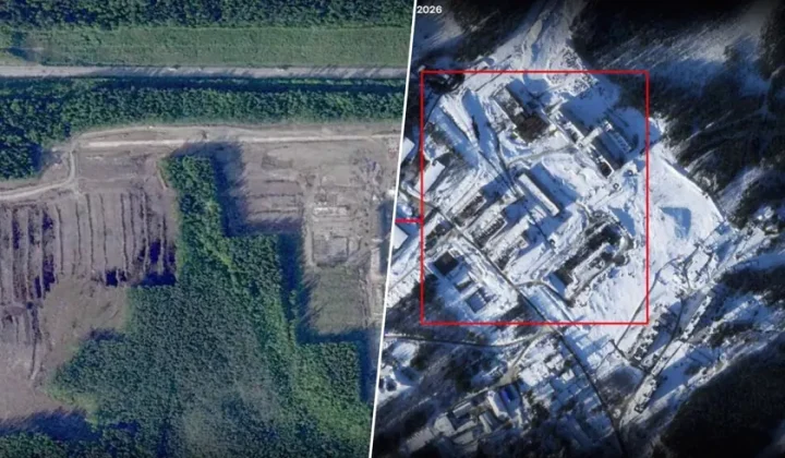
Satellite Imagery Reveals Significant Russian Military Buildup Near NATO Borders
New satellite data and intelligence analyses indicate Russia is expanding military infrastructure and preparing for a substantial troop deployment in areas bordering…
Read article
Volkswagen Executives Signal Existential Threat Amidst Internal Survey Findings
A leaked internal survey reveals that a majority of Volkswagen's top executives believe the company's very existence is at risk, citing challenges…
Read article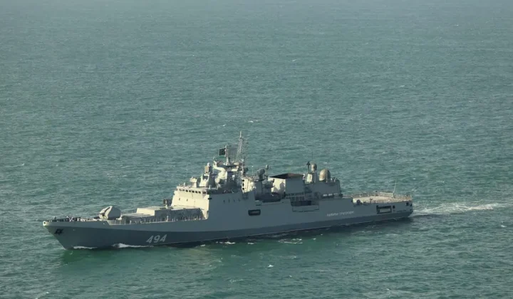
Russian Frigate Fires Warning Shots Near British Yacht in English Channel
An incident involving a Russian warship and a British yacht in the English Channel has raised concerns about escalating military tensions in…
Read article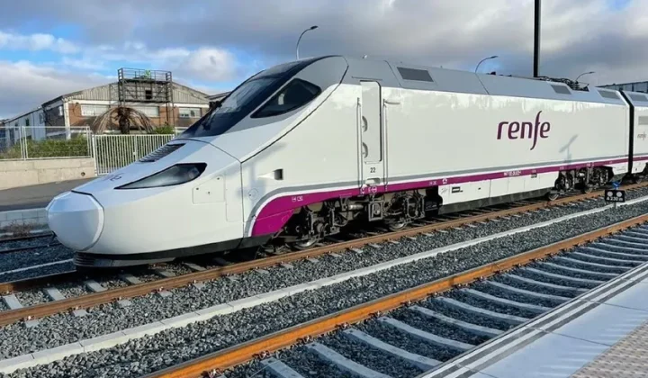
Spanish High-Speed Rail Faces Downturn: Nearly 20% Passenger Drop Post-Adamuz Accident
Data reveals a significant decline in high-speed rail ridership in Spain during the first four months of 2026, attributed to infrastructure issues…
Read articleWiki relacionada
Understanding Large Language Models (LLMs)
An introduction to Large Language Models (LLMs), their architecture, capabilities, limitations, and real-world applications in AI.
Read article
Understanding LLM Context Windows
An in-depth look at Large Language Model context windows, their importance, limitations, and how they impact AI applications.
Read article
Comprendiendo los Modelos Llama 3: Una Visión Integral
Explore la familia de modelos Llama 3, detallando su arquitectura, capacidades, limitaciones y aplicaciones prácticas en el desarrollo de IA.
Read article
Comprensión de los Modelos de Lenguaje Grandes (LLM)
Una mirada en profundidad a los Modelos de Lenguaje Grandes (LLM), su arquitectura, capacidades, limitaciones e impacto en el desarrollo de la…
Read article